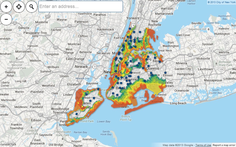
FEMA reveiled updated flood zone maps two weeks ago, which doubles the previous estimated number of at risk New Yorkers to 400,000 residents and 70,000 buildings. These numbers are still proposed, and will take up to two years of reviews to become official, after which building regulations will be affected.
Proposed updated flood zone map, courtesy of http://maps.nyc.gov/hurricane/
At the city level, Mayor Bloomberg addressed the escalating risk of rising sea levels and powerful storm surge by proposing a $20 billion storm protection plan following the announcement of the newly proposed maps. The recommendations include building seawalls and a protective “Seaport City” south of the Brooklyn Bridge. The full report can be found here.
In the meantime, residents are already affected financially by increased insurance premium rates, and faced with the costly dilemma of raising their houses above the base flood elevation. As a green builder, Eco Brooklyn is involved in several projects focused on the effects of rising flood waters and nearby contamination. Residences in flood prone areas are constructed with the expectation of flooding to the first floor. We therefore choose to build through processes that reduce water damage, such as waterproof installation and minimizing the use of sheetrock. We encourage the cellar to be used largely for storage only and elevate all mechanical items such as the boiler to above the ground level. Total protection is not ensured, but the reduction of damage risk is the best that can be done for smaller residences where moving out is not an option, and elevating an entire house is too costly a measure.
In light of these proposed flood zone maps, Eco Brooklyn highly recommends that residents assess their new risk level and what preventative measures can be undertaken to ensure the future safety of their families.
-Liza Chiu

